
Page 3

| Grant's and Bill's 2012 Hawaii Scrapbook |
|
| |
Kauai Page 3 |
|
Kauai . |
 |
|
||||
Helicopter tour
|
|
|||||||
|

|
|||||||
This was our little airport, obviously not Kauai's international airport. Notice the beach just above the airfield and ponds. We spent a few hours there. It's a beautiful beach and kind of a secret with the locals, no tourists. (And we didn't hear one plane or helicopter.) |
 |
||
This is a coffee plantation, the largest on the islands. Even though Kona coffee from the Big Island is more famous, Kauai grows more coffee than all the other islands put together. |
 |
||
Entering our first valley. |
 |
||
Buckle up and click here for the 1st video |
 |
||
Some valleys we flew into from the south and west started out looking quite dry, like this..... |
 |
||
...and further up the valleys we saw scenes like this.... |
 |
||
....and when we got to the heads of the valleys, they looked like this > Their heads were in the clouds. :-) The reason for that is -- Most of the large valleys cut all the way to the center of the island, which happens to be the wettest place on Earth. And that is why, even if it's a perfectly clear day elsewhere on the island, the center of the island will likely be shrouded in clouds, resulting in the rain that forms all these waterfalls. The scale of these cliffs is huge. It's impossible to capture the entire height of the cascades. Some of then start hundreds of feet above the cloud level. In this shot, we can just make out an upper section of one of these falls in the cloud level way above the two middle falls. This particular valley is over 2,200 feet deep. We saw other valleys with a 3,000 foot drop. |
 If you look for the twin falls (above left and below right) you can see how these two shots (above and below) connect. The following two shots are almost vertical of each other.   |
||
| Click
here for Helicopter Video 2. |
|||
Waimea Canyon We drove here twice because the views are stunning. This shot is just a small part of the largest valley, and the most colorful. It's in the driest part of the island and looks somewhat similar to the Grand Canyon. Some refer to it as "The Grand Canyon of the Pacific". But the layers here are not sedimentary rock as in Arizona; they are successive lava flows. The road goes along the ridge in the background and continues all the way to where you can look down on the ocean on the other side of the island. |
 |
||
Click here for Kauai Helicopter Video 3 ( Caution: This video may cause vertigo.). |
 |
||
| THE NORTH COAST This shot is where we came over the last ridge out of the dry canyons and BAM!, just like that we were zooming down and out over the ocean. What a rush! This is the remote section of northern Kauai called the Na Pali Coast. In the photos, you can see why no roads can be built here. This is the windward side of the island, so it often rains here. And on our day, it was also quite blustery, which made for an even more exciting ride. In the second picture here, the black bar at the top of is the rotor blade of the helicopter. (In case you were wondering.) |
  |
||||
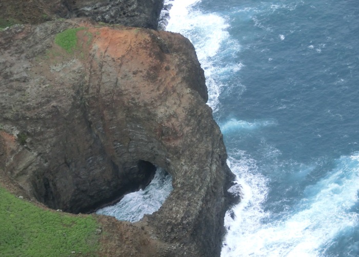
| This is looking down at some sea caves. The roof of the biggest cave collapsed and formed this nice round hole you can only see from above. Love those colors in this photo! |
 |
||||
When the helicopter descended, we could see the huge sea cave close up. |
 |
||||
This beach and sea cave are where the 1970's King Kong movie was filmed (the one with Jessica Lange). There are 3 shots of it from different angles as we circled it. |

|
||||
More shots of the Na Pali Coast. Checking the larger photo on the left -- The farthest ridge is the one used as "Bali Hai" in the movie "South Pacific". (The borrowed small photo below that one is to remind us of the view in the movie.) The photo on the right shows a giant sea cave, and, in the background, you can see the next valley we were about to explore. |
|
||||
The last bit of the North Coast we saw before we headed into the north shore valleys and south from there was picturesque Hanalei Bay, which, on a clear day has one of the most beautiful beaches anywhere.. |
 |
||||
|
 |
||||
Even though the cliffs are almost vertical, the climate allows almost every inch of slope to be covered with vegetation. This photo is the outside edge of the central crater and the photo below is from inside the huge crater, now millions of years extinct. It is impossible to hike here due to the heavy rains and wet ground. The only possible way to see this central crater is by helicopter. |
 |
||||
When the helicopter circled inside the crater with walls thousands of feet high and surrounded by waterfalls, it was a real-life "Avatar" (movie) moment! It was an amazing climax to the helicopter tour. We would love to do this tour again! |
 |
||||
| Go to PAGE 4 Click here |
Return
to PAGE 1 Return to PAGE 2 |


